Garmin Geko 301 User Manual
Browse online or download User Manual for GPS receiver Garmin Geko 301. Garmin Geko 301 User Manual
- Page / 68
- Table of contents
- BOOKMARKS
- Personal Navigator 1
- © Copyright 2003 2
- Product Registration 3
- Table of Contents 4
- FCC Compliance 5
- Warnings and 6
- Cautions 6
- Software License 9
- Agreement 9
- Introduction 10
- Maintenance 10
- Installing Batteries 11
- Features and 12
- Down to the 13
- Main Pages 13
- Elevation Options 14
- Trip Options 14
- Satellite Options 14
- Map Options 14
- Satellite Page 15
- What is the 15
- Satellite Page? 15
- Advanced 17
- Orient Sky 18
- Northward 18
- About Geko 18
- What can I fi nd 19
- Map Page 19
- Navigation Page 22
- Show me the 22
- Navigation Options 23
- What is my elevation? 26
- Elevation Page 26
- Elevation Page Options 27
- Elevation Plot by 28
- Distance 28
- ‘View Points’ Option 28
- Change all four fi elds 31
- Trip Computer 32
- Data Field Options 32
- Menu Page 33
- What can the Main 33
- Menu show me? 33
- Waypoints 34
- The ‘PROJECT 37
- WAYPOINT’ option 37
- The ‘EDIT NUMBER’ fi eld 37
- Tracks Setup 39
- Track on Map Page 40
- “FOLLOW” choice list 42
- “Navigation” Page’s pointer 43
- Time Format Menu 46
- Setup Menu Time Menu 46
- Time Zone Menu 46
- The Daylight Savings 47
- Display Option 48
- Backlight Field 48
- Backlight Settings 48
- Adjust Contrast 48
- Bar UP or DOWN 48
- Setup Page 49
- Distance/Spd Units 50
- Elevation Units 50
- Interface Option 51
- Interface Menu 51
- Battery Setting 55
- Appendix A 57
- Specifi cations 57
- Appendix B 58
- Accessories 58
- Appendix C 59
- Wiring Diagram 59
- eld 34 65
Summary of Contents
owner’s manualandreference guideGeko™ 301Personal Navigator®Geko 301 Cover.indd 1 5/19/2003, 4:21:53 PM
viiiGPS CLEANINGThe Geko 301 is constructed of high quality materials and does not require user main-tenance other than cleaning. Clean the unit usin
ixIntroductionInstalling BatteriesINSTALLING THE BATTERIESThe Geko 301 operates on two AAA batteries (not included), installed in the back of the unit
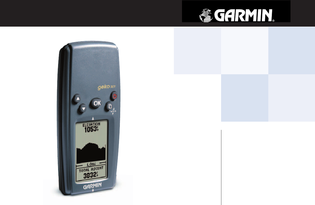
xIntroductionFeatures and ButtonsOKButtonLCD Display(with backlight)POWER ButtonUP ButtonDOWN ButtonPAGEButton(CompassOn/Off)Geko 301 Buttons:The POWE
1MAIN PAGESAll of the information needed to operate the Geko 301 is found on six main ‘pages’ (or display screens). These pages are the Satellite, Map
2Main PagesGeko 301 Menu DiagramMENU NAVIGATIONYour Geko 301 allows you to navigate through menus quickly and effi ciently using a combination of the P
3Satellite PageWhat is the Satellite Page?The Satellite Page displays the Geko 301 looking for and gathering all the necessary information from satell
4The Options on the Satellite Page allow you to customize the page in several ways. All options stem from the default Normal Skyview Page. Here are
5Satellite PageAdvancedSkyviewTo adjust the contrast from the Satellite Page:1. In Normal or Advanced Skyview, press the OK Button to access the ‘OPT
6Satellite PageAdvancedSkyviewTo select Orient Sky Northward/Ahead:1. In Advanced Skyview, press the OK Button to access the ‘OPTIONS’ menu.2. Press
7What can I fi nd on the Map?Map PageThe Map Page shows where you are (the animated fi gure) and provides a picture of where you are going. As you trave
Except as expressly provided herein, no part of this manual may be reproduced, copied, transmitted, disseminated, downloaded or stored in any storage
8Map PageOptionsWhen you select ‘Orient Map Northward’ the fi gure icon is replaced by a ‘direction’ triangle. The tip of the triangle tells you the ge
9Selecting ‘PAN TRACK LOG’ from the Map Page options allows you to move the pointer to any point on the track log and then create a Waypoint or naviga
10Navigation PageShow me the way!The Navigation Page provides active guidance with a rotating compass ring that shows your course over ground (track)
11Note: The default setting on the Geko 301 has the Compass turned OFF.Navigation PageOptionsNavigation OptionsWhen you are not on an active GOTO, Tra
12To Stop Navigation:1. Press the OK Button to open the Options Menu.2. Press the Up Button to highlight the ‘STOP NAVIGATION’ fi eld and press the O
13Navigation PageOptionsThe Electronic Compass must be calibrated when you fi rst use the Geko 301 and after new batteries have been installed. The a
14The Elevation Page provides the user with the current elevation, rate of ascent/descent, a profi le of elevation changes over distance or time, or a
15The Status is located at the top of the page and displays the current elevation. The Profi le Field is located in the center of the page and displays
16Elevation PageOptionsTo adjust zoom ranges:1. From the Elevation Page, press the OK Button to use the Options Menu to choose ‘PLOT OVER TIME’ or ‘P
17Elevation PageOptionsTo reset the elevation data and max elevation fi elds:1. From the Elevation Page, press the OK Button to open the Elevation Opt
iIntroductionProduct RegistrationDON’T JUDGE A BOOK BY ITS COVERAre you familiar with the above phrase? Well, here is a new one: don’t judge GPS perfo
18Elevation PageOptionsDATA FIELDSThe user-selectable data fi eld found at the bottom of the screen can display different kinds of elevation data. Fol
19Four data fi elds of your choosing display on the Trip Computer Page. The default fi elds are shown but by selecting the ‘CHANGE FIELDS’ option you ca
20Trip ComputerData Field Options • Elevation—the measurement of height above mean sea level.• Glide Ratio—the ratio of horizontal distance travelled
21Menu PageWhat can the Main Menu show me?With the Menu Page you can manage Waypoints, Tracks and Routes, play Games, Calibrate the compass or altimet
22Menu PageWaypointsThe EDIT LOCATION Page displays on-screen instruc-tions explaining how to edit the waypoint location.The Mark Waypoint Page allow
232. Press the UP or DOWN Button to highlight the ‘ELEV’ fi eld and press the OK Button to display the ENTER CORRECT ELEVATION Page. 3. Use the UP or
242. Select ‘DELETE ALL’ and press the OK Button. A confi rmation message box displays asking if you really want to delete all waypoints. Press the UP
25The Geko 301’s Project waypoint feature can create a waypoint at a specifi ed distance and bearing using either your current position or an existing
26The Geko 301 draws an electronic breadcrumb trail or ‘track log’ on the Map Page as you travel. The track log starts recording as soon as the Geko 3
27To save a track for navigation later:1. From the ‘MENU’ Page, press the UP or DOWN Button to highlight ‘TRACKS’ and then press the OK Button to di
Table of ContentsIntroductionINTRODUCTION... i-xProduct Registration...iTab
28Menu PageTracks5. Press the UP or DOWN Button, to highlight the correct character and press the OK Button to accept that character. 6. Continue un
29The Geko 301 allows you to navigate using one of three methods: Goto, TracBack and Route. The Goto method of navigation was briefl y discussed on pag
30Menu PageRoutesIn either case, you can navigate to a destination using ‘ROUTE’ if a route has more than two waypoints. A single waypoint route is on
31To remove a waypoint from the ‘ROUTES’ list:1. From the ‘MENU’ Page, press the UP or DOWN Button to highlight ‘ROUTES’ and press the OK Button to d
32The Geko 301 offers fi ve games with you, the user, as the key participant. The Games Page shows the listing, which includes: Gekoids, Geko Smak, Mem
33Menu PageGamesMemory RaceTo win the Memory Race, remember which square has which symbol then clear the board by matching all of the two symbol sets
34Setup PageTime PageThe Setup Page allows you to customize the Geko 301. On the Setup Page you can change coordinate systems, map datums, and distanc
353. Press the UP or DOWN Button to scroll through the selections and press the OK Button when you have found the correct Time Zone. 4. Press the PA
36Setup PageDisplayLight TimeoutThe ‘LIGHT TIMEOUT’ option allows you to set the display backlight timeout (STAYS ON, 15 or 30 seconds, and 1 or 2 min
37Setup PageUnitsUsing the Geko 301 with a paper map increases the navigation capabilities of each. To use a map in conjunction with the Geko 301, you
iiiThe Geko 301 complies with Part 15 of the FCC interference limits for Class B digital devices FOR HOME OR OFFICE USE. These limits are designed to
38Setup PageUnitsTo change the Map Datum:1. From the MENU Page press the UP or DOWN Button to highlight ‘UNITS’. Press the OKButton to display the UN
39Setup PageInterfaceInterface Settings (Input/Output)The ‘INTERFACE’ Settings Page allows you to use your Geko 301 with external NMEA devices, DGPS b
40Setup PageHeadingHeading PageThe Heading Page allows you to change the heading angle to degrees or mils (default is degrees), your desired speed the
41Setup PageBecause a compass points to Magnetic North, not True North, maps indicate the difference between True and Magnetic North with a measuremen
42Setup PageSystemThe System Page allows you to choose from four modes of GPS operation (Normal, WAAS, Battery Save, Demo), to turn the Electronic Co
43SystemSetup PageTo change the GPS mode:1. From the MENU Page press the UP or DOWN Button to highlight the ‘SYSTEM’ fi eld. Press the OK Button to di
44LanguageThe Geko 301 offers 16 different languages in which to view the information. To change the language:1. From the MENU Page press the UP or D
45PhysicalCase: Fully-gasketed, high-impact plastic alloy, waterproof to IPX7 standards (waterproof to 1 meter for 3
46Appendix BStandard AccessoriesOwner’s Manual and Reference GuideQuick Start GuideOptional AccessoriesBelt ClipAttaches to the back of the unit for c
47Appendix CWiring DiagramInterface formats are selected from the SETUP Page. The input/output lines on your Geko 301 are RS-232 compatible, allowing
ivCAUTION: Use the Geko 301 at your own risk. To reduce the risk of unsafe opera-tion, carefully review and understand all aspects of this Owner’s M
48IndexAAbout Geko 6Accessories 46Advanced Skyview 3Advanced Skyview Options 5Altimeter 14–18, 43Altitude 14–18Arrival Time 12, 20Auto Zoom On/
49Index(Data Fields cont.)Arrival Time 20Average Speed 12Bearing 20Date 12Final Distance 20Glide Ratio 18Heading 12Location 12, 20Maxium Desce
50Index(Final cont.) ETE 20Final Destination 20Final Distance 12GGamesGekoids 32Geko Smak 32Memory Race 33Nibbons 33Virtua Maze 33GARMIN DGPS
51IndexMaximumAscent 18Elevation 18Max Speed 12, 20Measure Distance 8Menu Page/Main Menu 21Minimum Elevation 18Moving Average 20Moving Time 20
52IndexProfi le Field 15Projecting a Waypoint 25RRegistration iReset 16Review Waypoint Page 24Routes 29–31RTCM/NMEA 39RTCM/TEXT 39RTCM IN 39SS
53IndexTo Course 20TracBack 28Tracks 26–28Track LogClear Track Log 26Delete a Saved Track 28Rename A Saved Track Log 27Save A Track For Navigati
Notes190-00297-02_0A.indd 54 5/19/2003, 4:20:40 PM
Geko 301 Cover.indd 3 5/19/2003, 4:22:20 PM
© Copyright 2003 Garmin Ltd. or its subsidiariesGarmin International, Inc.1200 East 151st Street, Olathe, Kansas 66062, U.S.A.Garmin (Europe) Ltd.Uni
vWARNING: For use in vehicles, it is the sole responsibility of the owner/operator of the Geko 301 to secure the unit so that it will not interfere w
viLIMITED WARRANTYThis Garmin product is warranted to be free from defects in materials or workmanship for one year from the date of purchase. Within
viiIntroductionSoftware License AgreementSOFTWARE LICENSE AGREEMENTBY USING THE GEKO 301, YOU AGREE TO BE BOUND BY THE TERMS AND CON-DITIONS OF THE FO
Related products and manuals for GPS receiver Garmin Geko 301
 (68 pages)
(12 pages)
(2 pages)
(60 pages)
(78 pages)
(2 pages)
(94 pages)
(16 pages)
(20 pages)
(36 pages)
(142 pages)
(24 pages)
(22 pages)
(68 pages)
(12 pages)
(2 pages)
(60 pages)
(78 pages)
(2 pages)
(94 pages)
(16 pages)
(20 pages)
(36 pages)
(142 pages)
(24 pages)
(22 pages)
 (16 pages)
© 2020, manymanuals.com. All rights reserved. | 0.496 s |
 Manymanuals.com
 Manymanuals.de
 Manymanuals.fr
 Manymanuals.it
 Manymanuals.pl
 Manymanuals.cz
 Manymanuals.es
 Manymanuals-pt.com
Comments to this Manuals